

The Future Airspace Strategy VFR Implementation Group (FASVIG) has just completed version 2 of its ‘Register of Significant VFR Areas’. The term VFR Significant Area is applied to a volume of airspace which has been identified as being particularly important to VFR operations. A VSA might take the form of a route, a zone or an area chosen for its particular importance to its VFR users. The objective is to highlight the importance of a particular area so that any future airspace development plans can take due account of the VFR activity. VSAs are not intended to block airspace development, more to make developers mindful of the importance of an area to VFR activity which otherwise might not be obvious.
The Future Airspace Strategy VFR Implementation Group (FASVIG) was formed at the end of 2013 as a collaboration between key general aviation interests including the flight training industry, sporting and recreational aviation, and commercial and military interests and the CAA.
To be recognised as a VSA, an area must meet one or more of various criteria which recognise the numerous uses VFR airspace is put to, including (but not limited to) being necessary for access to airfields and routes, training areas, manoeuvre room, competition and airsports use, scarcity (locally and nationally), and important because of the number of users. VSAs do not need to meet all criteria but need to be nationally, or regionally, important for VFR operations for one or more of the criteria. Given the different densities of controlled airspace around the country, these criteria will vary from region to region so, for example, the South East will apply different weight to some criteria than, say, the North of Scotland. There is also a recognition that if an airfield is ‘choked off’ in that access routes are severely limited, this will affect the viability of the airfield and make it more vulnerable to acquisition by housing developers.
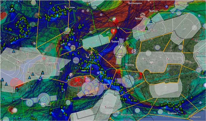
Each VSA is depicted as an overlay on a CAA half-million chart, so the interrelation between the airfields within the VSA and the nearby controlled airspace is clearly visible. The criteria which are applicable to each VSA are also listed, with a short explanation as to how or why they are relevant. So, for example, the ‘Heathrow/Luton Gap’ recognises the importance of the area as a local flying area and access route for airfields such as Elstree and Denham, plus various strips and helipads, and acknowledges that any further encroachment would seriously affect the viability or operations at these airfields. Similarly, the ‘Brize Norton-Heathrow-Luton Gap’ recognises the significant amounts of training and business activity from Oxford, Wycombe Air Park and White Waltham, together with gliding from Halton, Bicester, Wycombe, Dunstable and others. This VSA is depicted via the alternative method of showing the VSAs, an overlay created by FASVIG for Google Earth:
Taken in conjunction with the numerous microlighting, parachuting and other airsports operating from bases in or adjacent to the area, it is also noted that it is also recognised as an important transit route for VFR traffic in general. The designation for this VSA cites an AAIB report into a mid-air collision between a Grob Tutor and a Cirrus glider in 2009 as evidence for the intensity of VFR traffic in the area, and comments that any further encroachment is likely to increase the risk of mid-air collisions.
The second edition of the FASVIG VFR Significant Areas Register, can be found at: docs.fasvig.info/Projects/MAS01/20170930-MAS01-0002-FASVIG-VSA-V2.pdf. It expands the number of VSAs developed in Version 1 and also introduces Google Earth as an alternative means of presenting VSAs.